New to Bakersfield
- Thread starter bogus311
- Start date
You are using an out of date browser. It may not display this or other websites correctly.
You should upgrade or use an alternative browser.
You should upgrade or use an alternative browser.
dirt bike dave
Sponsoring Member
- May 3, 2000
- 5,349
- 3
Hello!
There is an MX track just outside the east side of town, but MX and my bum knee don't get along, so I don't ride there.
There are some excellent trail riding spots that are red sticker legal in the Sequoia National Forest. You can check out the forest service website for more info. You wil lneed a spark arrestor.
The closest good trail spot to town is on Hwy 178, through Kern Canyon, approx. 30 minutes+- from downtown Bakersfield and 10 miles this side of Lake Isabella. I'm pretty sure it's red sticker legal. It's on the north side of the Hwy. There is a gate and trail head for 4wd trail heading away from the Hwy, and a single track trail paralleling the Hwy. Most of the single track is to the north, and the trails extend up to about 7,000 feet, toward Shirley Meadows/Alta Sierra Ski Resort. The lower elevation trails are good in winter, but hot and dusty in summer. If you don't mind a longer drive, you can stage at Evans Camp, gettign there via Rancheria Road or Hwy 155. This will be aprrox. 2 hour drive from town, though.
For summer stuff, some of the very best riding in California is at the Kern Plateau, aka Kennedy Meadows. Red Sticker legal. There are multiple places to stage and lots of trails. Mostly single track. From Bakersfield, the closest of the best trails are near Sherman Peak, and about 100 miles from Bakersfield, just over 2 hour drive (come in from Kernville via Sherman Pass Road). You can stage about 9,000 feet; trails range from 4,000 feet to 9,900 feet elevation, so you might want to adjust your jetting if you are on a small two stroke. The open class 4 stroke guys don't usually bother rejetting.
Much of this is technical single track, some very fun jeep trails. A few of the trails are pretty challenging if you inexperienced at that type of riding, or if your leg is a real mess. But many of the trails are simply excellent. They are snowed in in winter. Usually perfect and moist in May - early July; open until the snow comes.
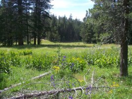
I was up there hiking with my kids last weekend. I'll try to post some pics. Still lots of wild flowers, not much water in the creeks.
In winter, most guys go out to the desert, like Jawbone, Dove Springs, etc...Red stikers OK out there during that season.
I have not been doing much riding lately, but I'd be glad to take you up there sometime. I've got a bum leg, too, and got fat lately as well, lol.
There is an MX track just outside the east side of town, but MX and my bum knee don't get along, so I don't ride there.
There are some excellent trail riding spots that are red sticker legal in the Sequoia National Forest. You can check out the forest service website for more info. You wil lneed a spark arrestor.
The closest good trail spot to town is on Hwy 178, through Kern Canyon, approx. 30 minutes+- from downtown Bakersfield and 10 miles this side of Lake Isabella. I'm pretty sure it's red sticker legal. It's on the north side of the Hwy. There is a gate and trail head for 4wd trail heading away from the Hwy, and a single track trail paralleling the Hwy. Most of the single track is to the north, and the trails extend up to about 7,000 feet, toward Shirley Meadows/Alta Sierra Ski Resort. The lower elevation trails are good in winter, but hot and dusty in summer. If you don't mind a longer drive, you can stage at Evans Camp, gettign there via Rancheria Road or Hwy 155. This will be aprrox. 2 hour drive from town, though.
For summer stuff, some of the very best riding in California is at the Kern Plateau, aka Kennedy Meadows. Red Sticker legal. There are multiple places to stage and lots of trails. Mostly single track. From Bakersfield, the closest of the best trails are near Sherman Peak, and about 100 miles from Bakersfield, just over 2 hour drive (come in from Kernville via Sherman Pass Road). You can stage about 9,000 feet; trails range from 4,000 feet to 9,900 feet elevation, so you might want to adjust your jetting if you are on a small two stroke. The open class 4 stroke guys don't usually bother rejetting.
Much of this is technical single track, some very fun jeep trails. A few of the trails are pretty challenging if you inexperienced at that type of riding, or if your leg is a real mess. But many of the trails are simply excellent. They are snowed in in winter. Usually perfect and moist in May - early July; open until the snow comes.
I was up there hiking with my kids last weekend. I'll try to post some pics. Still lots of wild flowers, not much water in the creeks.
In winter, most guys go out to the desert, like Jawbone, Dove Springs, etc...Red stikers OK out there during that season.
I have not been doing much riding lately, but I'd be glad to take you up there sometime. I've got a bum leg, too, and got fat lately as well, lol.
dirt bike dave
Sponsoring Member
- May 3, 2000
- 5,349
- 3
Bogus - we absolutely should ride sometime soon. I'm out of town the next two weekends on family stuff, but a day trip sometime after that might work.
There are some good trails just south of the ski area, on both sides of Rancheria Road. The trail and road markings in this area are not too good. There is not a good trail map for this part of the forest (the Sequoia Natioal Forest Map is almost useless for these trails). So some of the trails are short or dead end, but some others are quite nice. It's probably dusty everywhere now. I was up there in May and the hihest trails were perfect.
There are trails out of Jawbone that go into the Piutes, and eventually hook up with some trails to Lake Isabella. This is a pretty long haul. I've never ridden those, but hear they are good. Some guys stage from the southside of Lake Isabella, ride down to Jawbone for gas, then back.
Some of the red sticker guys you see are going out to he track, or just riding the private land in the hills (used to be very common and allowed on the east side of town, but now that is pretty much shut down). So either they know someone with land, or are trespassing. There are some oil fields out near Taft with trails that people ride in.
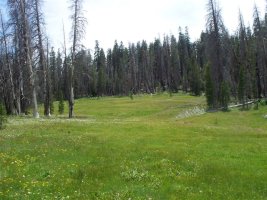
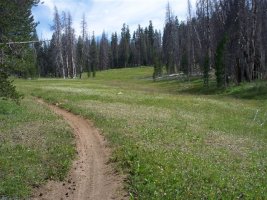
Anyways, here are some pics I took last Saturday at the Kern Plateau. This is Corral Meadow, about 8,500'. I'll often stage just above there. There was a big fire up there 7 or 8 years ago, and the meadow was like a fire break, so some areas still show the burn.
There are some good trails just south of the ski area, on both sides of Rancheria Road. The trail and road markings in this area are not too good. There is not a good trail map for this part of the forest (the Sequoia Natioal Forest Map is almost useless for these trails). So some of the trails are short or dead end, but some others are quite nice. It's probably dusty everywhere now. I was up there in May and the hihest trails were perfect.
There are trails out of Jawbone that go into the Piutes, and eventually hook up with some trails to Lake Isabella. This is a pretty long haul. I've never ridden those, but hear they are good. Some guys stage from the southside of Lake Isabella, ride down to Jawbone for gas, then back.
Some of the red sticker guys you see are going out to he track, or just riding the private land in the hills (used to be very common and allowed on the east side of town, but now that is pretty much shut down). So either they know someone with land, or are trespassing. There are some oil fields out near Taft with trails that people ride in.
Anyways, here are some pics I took last Saturday at the Kern Plateau. This is Corral Meadow, about 8,500'. I'll often stage just above there. There was a big fire up there 7 or 8 years ago, and the meadow was like a fire break, so some areas still show the burn.
dirt bike dave
Sponsoring Member
- May 3, 2000
- 5,349
- 3
dirt bike dave
Sponsoring Member
- May 3, 2000
- 5,349
- 3
http://www.fs.fed.us/r5/sequoia/recreation/ohv-osv/cm/cm_ohv_map.html
Has a link to the map panels for the Cannel Meadow Ranger District / kennedy Meadows. You can't get a printed copy of this map anymore, but you can print your own and paste the panels together. There is another map frequently available at trail heads and ranger stations, but it's not as good.
The guys from LA area that ride here tend to come up Hwy 395 to the east side , and stage and ride the eastern half. From Bakersfield, the quickest access is from the west, and many of the western trails are lightly used and awesome.
There is not currently an online map for the area near the ski resort (Greenhorn Ranger District). The maps that used to be available at the trail heads and ranger station were very poor. Don't know when or if they will have new maps - I think some in the USFS are trying to discourage OHV use, so they don't make it easy on the riders. In any event, you can ride from near the ski area to a little area called Keyesville close to Lake Isabella. It's a pretty big area, but mostly 4wd trails.
Much of the Piute area is still closed following a fire last year.
There is also an area of 4wd trails in the Breckenridge area not far from Bakersfield that may be red sticker legal, but I don't think many dirt bikers go there. I've never been.
For areas with red stricker restrictions, there is Hungry Valley and the adjacent National Forest. These trails are pretty much beat. Some of the forest trails are good, but not as good as Kern Plateau.
Another area about an hour SW from town is Ballinger Canyon, on Hwy 33 just south of Hwy 166. Near where Kern/Santa Barbara and San Luis Obispo counties join. About 75 miles fo trails, maybe 25 miles of good trails. Gets hot and dry in summer, pretty good in winter and spring. I think it has red sticker restrictions.
I haven't been on here in at least a year, but had a little extra time today so I dropped by. Sorry I'm a little late to this thread, you may have already gotten all this info, but I'll give my .02 anyways. As Dave mentioned, the best near by riding in the summer is Keysville (access from Hwy 178 or near Shirley Meadows off of Hwy 155). You can be at the trail head within an hour, get a few hours of riding in and be home early afternoon.
This website links you to the forest service trail maps. http://krvr.org/index.php?option=com_joomlaboard&Itemid=26&func=view&view=threaded&id=475&catid=4 The Breckenridge map has all of the Keysville trails on it. http://www.fs.fed.us/r5/sequoia/projects/ohv_route_designation_strategy/maps/2-Breckenridge.pdf The parking area that Dave mentioned is at Hwy 178 and trail 27S08, near the area marked Sandy Flat I believe.
Once it cools down and red sticker areas open up, there are some good trails out of the back of Hungry Valley into the forest, and Ballinger is a fun day of riding. Then there is the desert, which provides many miles of open riding areas. My favorite is the Spangler Hills area off of Hwy 395 near Ridgecrest.
I hear great things about Kennedy Meadows, but have never made it up there. I've always been a desert guy, but have recently been getting converted to riding in the mountains.
Dave, how come we've never met? You've done some riding with placelast right?
deano...
dirt bike dave
Sponsoring Member
- May 3, 2000
- 5,349
- 3
Yep!
Used to ride with Placelast sometimes at Ballinger or Hungry Valley before he moved. John is a great guy; would love to ride with him again sometime.
Honestly, I've been doing way too little riding lately - busy with work and family. No riding for at least another two weekends, but I'm hoping there will be some monsoon weather bringing some rain to the Kern Plateau in early/mid September.
The trails at Kennedy Meadows are awesome. Better than the best of the Keyesvill/Shirley Meadows trail, IMO. From the valley, the closest access is a network of trails at the west of the riding area, neare Sherman Peak. Good stuff!
BakersfieldOffroad
Member
- Oct 20, 2009
- 1
- 0
Working to create a community
Greetings, I was wondering if there are any organized groups of riders here in Bakersfield? Whether you run under a club or group name, I am working on a community which will give riders and drivers the ability to communicate and plan things together within Bakersfield and the outskirts.
Greetings, I was wondering if there are any organized groups of riders here in Bakersfield? Whether you run under a club or group name, I am working on a community which will give riders and drivers the ability to communicate and plan things together within Bakersfield and the outskirts.
Similar Topics
- Replies
- 0
- Views
- 343
M
- Replies
- 0
- Views
- 92
M
C
- Replies
- 0
- Views
- 121
C
FRESH VIDEO
-
KTM, Husqvarna & GasGas TBI Power Valve Calibration #shorts
Tue, 30 Apr 2024 14:58:43 CDT
-
Sexton’s Mechanic: Why Did KTM Let Brandon Zimmerman Go After Nashville Mechanical?
Tue, 30 Apr 2024 14:00:13 CDT
-
“I Love the Dangers I Put Myself Through!” | Steve Caballero on the SML Show
Tue, 30 Apr 2024 13:00:07 CDT
-
PulpMX Show 583 – Malcolm Stewart, Daxton Bennick, Mitch Payton & Justin Rodbell w/ Michael Lindsay
Mon, 29 Apr 2024 07:15:59 CDT
-
Weege Show: Philadelphia Post Race with Stew and More
Sat, 27 Apr 2024 23:36:33 CDT
-
Weege Show: Philadelphia Supercross Preview
Fri, 26 Apr 2024 20:40:38 CDT
-
Philadelphia PulpMX Fantasy Preview & Strategy | Before You Pick! 2024 ft. RotoMoto
Fri, 26 Apr 2024 13:01:18 CDT
-
Jason Lawrence VS Chad & Tate Reed! Battles at Dade City MX
Thu, 25 Apr 2024 19:00:22 CDT
-
Fly Racing Moto:60 Show – Philadelphia SX 2024 with Zach Osborne & Daniel Blair
Thu, 25 Apr 2024 11:48:15 CDT
-
When is the right time to move up to the 450? | Lewis vs. Kellen: More Than Moto Ep. 13
Tue, 23 Apr 2024 17:01:26 CDT